-
Thetford Priory
The remains of The Cluniac Priory of Our Lady of Thetford The Cluniac Priory of Our Lady, Thetford, was first founded on the Suffolk side of the Little Ouse river by Roger Bigod in the early twelfth century during the reign of Henry I. Bigod founded the Priory instead of making a pilgrimage to the…
-
From Margins of Empire at Ely Museum 22 Jan – 26 Jun
This second-century AD skillet was found in Prickwillow, Isle of Ely, Cambridgeshire in1838. Copper-alloy decorated with copper and niello inlay and tin-plating.
-
From Margins of Empire at Ely Museum 22 Jan – 26 Jun
This first-century Roman cavalry combat helmet was discovered at Witcham, Cambridgeshire. Tinned copper-alloy. On loan from the British Museum.
-
Extramural Venta Icenorum
Venta Icenorum was the civitas-capital of the Iceni tribe, and the site of the remains of the Roman town is located about four miles south of Norwich, on the east bank of the river Tas, at Caistor St Edmunds in Norfolk. The Iceni, a British tribe with a territory which covered present-day Norfolk and parts…
-
“The Marlow Warlord”
ANGLO-SAXON WARLORD FOUND BY DETECTORISTS COULD REDRAW MAP OF POST-ROMAN BRITAIN The burial, on a hilltop site near with commanding views over the surrounding Thames valley, must be of 6th century AD, archaeologists from the University of Reading believe. The ‘Marlow Warlord’ was a commanding, six-foot-tall man, buried alongside an array of expensive luxuries and weapons,…
-
A14 update and the Huntingdon bypass – discoveries
Anglo-Saxon settlement and Roman army camp found in A14 bypass dig It’s taken more than 700 years, but the medieval villagers of Houghton in Cambridgeshire have had the last laugh: the foundations of their houses and workshops have been exposed again, as roadworks carve up the landscape they were forced to abandon when their…
-
Late Iron Age Skull
Dog walker finds human skull A dog walker has come across an unexpected find whilst out in Somerset. Roger Evans found a ‘well-preserved’ human skull whilst walking along the banks of the River Sowy. He reported his findings to the police and it was analysed. After months of research, results revealed it belonged to a…
-
St John the Baptist Church in Reedham may be Roman fortlet
A Norfolk church may have begun life as a Roman fortlet protecting supplies on their way to Hadrian’s Wall. Trevor Heaton hears how ‘keyhole archaeology’ is solving the riddle of Reedham. Sometimes things can hide in plain sight. But that doesn’t it make any easier to tell their story. For centuries, researchers and historians have…
-
Vindolanda boxing gloves
“Now, whoever has courage and a strong and collected spirit in his breast, let him come forward, lace on the gloves and put up his hands. (5.363-364) ― Virgil, The Aeneid Roman boxing gloves unearthed during an excavation near Hadrian’s Wall have gone on public display. Experts at Vindolanda, near Hexham, in Northumberland, believe they are “probably the…
-
Bamburgh Castle find
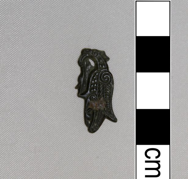
Bamburgh dig uncovers unique find The continued archaeological investigation of Bamburgh Castle , once the palace site of the early medieval kings of Northumbria, has revealed a marvellous new find of national significance. The copper alloy fragment is small, 23mm by 12mm, but beautifully decorated with an intricate zoomorphic representation of a bird, characteristic of…

Antiquarian's Attic
"A Farrago of Antiquities routed out of the Rusts and Crusts and Fusts of Time!"

You must be logged in to post a comment.